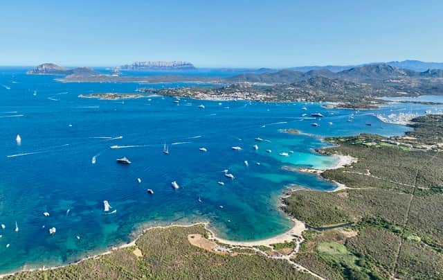
Aerial view of Porto Rotondo bay — the same Mediterranean waters that wrap the La Maddalena Archipelago 60 km to the north. Photo RENTAL12.
Sardinia's 3 Best National Parks & Reserves: La Maddalena, Molentargius, Gorropu
A trilingual guide to Sardinia's three standout protected areas — an archipelago of 60+ islands, the Mediterranean's largest resident pink-flamingo colony, and one of Europe's deepest canyons. Walked, verified and dated 2026 by RENTAL12 in Olbia.
Quick Guide
Sardinia has 3 standout protected areas, each totally different: La Maddalena Archipelago (60+ islands, 180 km of coast, ferry 15 min from Palau), Molentargius–Saline (Cagliari, the Mediterranean's largest resident pink-flamingo colony, free entry), and Gola di Gorropu (one of Europe's deepest canyons, 500 m walls, hiking from Dorgali). All three are reachable as a day or overnight trip from Olbia.
Live tools for your Sardinia parks trip
Real-time helpers that update every day with current Sardinia conditions.
1. Choose your park
Quick answer: Pick by what you want from the day. La Maddalena = islands and beaches by ferry. Molentargius = free birdwatching minutes from Cagliari. Gorropu = a serious canyon hike from Dorgali. Tap a card to see best-for, difficulty and transport.
La Maddalena
Best for islands + beaches
WetlandMolentargius
Best for free birdwatching
MountainGorropu
Best for canyon hiking
Quick-pick summary
- La Maddalena — Easy day trip, ferry from Palau 15 min, swimsuit + walking shoes, allow 1 full day.
- Molentargius — Half-day, free entry, walking or cycling on flat paths, binoculars recommended.
- Gorropu — Full day, requires car + 2 h hike each way, sturdy shoes + 2 L water per person, €6 entry.
La Maddalena — deeper detail
Best for: archipelago boat trips, Caprera (Garibaldi's house museum), Cala Coticcio "Tahiti" beach (permit required), Spiaggia Rosa boat-view. Difficulty: easy — suitable for families. Transport: Delcomar / Maddalena Lines ferry from Palau every ~30 min, €5.50 foot passenger; car ferry available. From Olbia: 1 h drive to Palau + 15 min ferry.
Molentargius — deeper detail
Best for: watching the Mediterranean's largest resident flamingo colony, cycling the salt-pan paths, free family wildlife day. Difficulty: very easy — flat, paved/gravel paths. Transport: 3 km from Cagliari centre by bus/bike; Cagliari Elmas airport 10 km. From Olbia: 2 h 45 min by car via SS131.
Gorropu — deeper detail
Best for: serious hiking, big-wall scenery, escaping the coastal crowds. Difficulty: moderate (Sa Barva approach) to hard (inner gorge with guide). Transport: car essential — trailheads at Sa Barva (Dorgali), Sedda ar Baccas (Urzulei) and Genna Silana pass. From Olbia: 1 h 45 min by car via SS125.
2. Parco Nazionale Arcipelago di La Maddalena
Quick answer: Sardinia's only national park covers 20,000 hectares of land and sea across 60+ islands off the north-east coast. Established 1 April 1994 by Italian law no. 10, it includes Caprera, Budelli (Spiaggia Rosa) and Spargi. Ferry from Palau every 30 min year-round, 15-20 minute crossing.
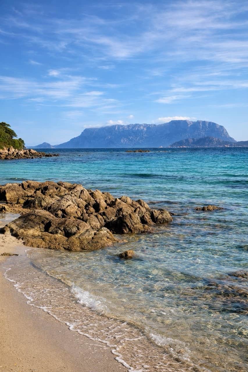
Beach near Olbia looking towards Isola Tavolara — the same protected marine ecosystem that extends north to La Maddalena. Photo RENTAL12.
Overview
The Parco Nazionale dell'Arcipelago di La Maddalena is Sardinia's only national park and one of just 24 in Italy. It protects more than 60 islands and islets off the north-east coast, the largest of which are La Maddalena (the only inhabited one, ~11,000 residents), Caprera (linked by a causeway, home to Giuseppe Garibaldi's house museum), Spargi, Budelli (famous for Spiaggia Rosa), Santa Maria, Razzoli and Santo Stefano. The park is part of the Pelagos Sanctuary for Mediterranean Marine Mammals (a tri-national French-Italian-Monegasque agreement protecting fin whales and dolphins) and has been on the UNESCO Tentative List since 2006.
How to visit
The main gateway is the town of Palau on the Sardinian mainland (1 h by car from Olbia airport via the SS125 coastal road). Delcomar and Maddalena Lines run ferries to La Maddalena town roughly every 30 minutes year-round; the crossing is 15–20 minutes. A foot passenger costs about €5.50 each way; bringing a car is around €25 return. From La Maddalena town a causeway leads to Caprera. To reach the other islands (Budelli, Spargi, Santa Maria) you need a boat tour — full-day organised tours from Palau or La Maddalena typically run April through October, €40–70 per person including lunch. Private boat charters are widely available too. For a deeper sea-by-sea read, our best beaches near Olbia & Golfo Aranci guide covers the closest mainland coastline.
Fees, permits & rules
General access to La Maddalena town and most beaches is free; the park funds itself through landing fees, boat-mooring tariffs and select-beach permits. The two most-regulated experiences:
- Cala Coticcio ("Tahiti") on Caprera — mandatory reservation via parcolamaddalena.it, daily cap of around 60 people, certified guide required for the inland trail; total cost roughly €3 park fee + €20–40 guide. Book at least 2 weeks ahead in July–August.
- Spiaggia Rosa on Budelli — landing has been forbidden since 1994 to protect the pink sand (formed from the crushed shells of a single foraminifer species). Viewing is by regulated boat tour only; anchoring within 70 m is also prohibited. Fines for breaches run €2,200–11,000.
Always check the official park site (lamaddalenapark.it) for the current season's rules — restrictions and boat-tour permits change year to year.
Best time to visit
Mid-May to mid-June and mid-September to mid-October are the sweet-spot windows: sea 21–25°C, fewer crowds, accommodation 30–50% cheaper than peak August. August itself is spectacular for warm water (peaks 27°C) but ferries get long queues, beach car parks fill by 09:30 and Cala Coticcio reservations are scarce. From November to March most boat tours pause and the park feels almost private. For a full month-by-month breakdown see our Sardinia weather guide.
3. Parco Regionale Molentargius–Saline (Cagliari flamingos)
Quick answer: A 1,600-hectare wetland on the edge of Cagliari, free to visit and home to the Mediterranean's largest resident pink-flamingo colony (Phoenicopterus roseus first nested here in 1993). Ramsar wetland since 1977, Regional Park since 1999, 230 bird species recorded. Walking and cycling paths open year-round.
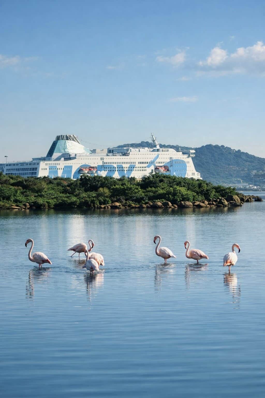
Pink flamingos in an Olbia lagoon — the same Mediterranean greater-flamingo species (Phoenicopterus roseus) whose largest resident colony lives at Molentargius near Cagliari. Photo RENTAL12.
Overview
Molentargius–Saline Regional Park wraps the eastern edge of Cagliari, between the city's outer suburbs and the long arc of Poetto beach. Its 1,600 hectares mix freshwater ponds, brackish lagoons and the former Roman-and-medieval salt pans that were industrial until 1985. Two pond systems matter: the freshwater Bellarosa Minore (rainwater-fed) and the brackish/salty Molentargius and Bellarosa Maggiore (the historical salt-production area). The park was designated a Ramsar wetland of international importance in 1977 — among the very first in Italy — and converted from industrial site to Regional Park in 1999. It is the most important wetland for waterbirds in the western Mediterranean, with 230 bird species recorded including herons, egrets, cormorants, marsh harriers, and of course pink flamingos.
For the full back-story on Sardinia's flamingos — where else to see them, when they migrate, why so many stay year-round — read our dedicated flamingos in Sardinia guide.
Why the flamingos are pink
Greater flamingos cannot manufacture their pink colour themselves — they get it from carotenoid pigments in what they eat, principally the Artemia salina brine shrimp and microalgae that thrive in the saline ponds. Colour intensity is therefore a direct reflection of diet quality: a flamingo on a richer carotenoid diet is more vividly pink. At Molentargius the resident colony began nesting here in 1993, and the park is now home to one of the most accessible flamingo populations in Europe — 5,000–10,000 birds depending on the season.
Fees, access & getting there
Entry to the park is free. Walking and cycling paths around the ponds are open year-round. Paid extras include guided walks, the historic Sali Choisy salt-works site visit and the electric-bus loop through restricted zones. The park is 3 km from Cagliari city centre — reachable by city bus (lines 5, 11, PF), bike (a dedicated bike path follows the canal), or foot from the Poetto beach side. Cagliari Elmas airport is 10 km away. From Olbia by car the drive is 2 h 45 min via the SS131.
Best time to see flamingos
Flamingos are present year-round, but the densest viewing is April–September when the breeding colony forms and chicks are visible. Early morning (07:00–09:00) and late afternoon (17:00–19:00) are optimum — calm light, birds active, lower temperatures. Bring binoculars (8x42 is ideal) and a long lens if you photograph — the closest birds are typically 50–100 m from the observation points. Avoid the middle of August midday: heat, fewer bird movements, and the city's Ferragosto crowds.
4. Gola di Gorropu canyon
Quick answer: One of Europe's deepest canyons, with limestone walls reaching 500 metres in the narrowest section. Located in the Supramonte between Urzulei and Orgosolo (Dorgali commune); protected since 1998. Three trails approach the canyon mouth (Sa Barva, Sedda ar Baccas, Genna Silana); €6 adult / €4 child entry; open 10:00–14:45, out by 15:30.
Overview
Gola di Gorropu is the deepest canyon in Italy and one of the deepest in Europe (the deeper Tara canyon in Montenegro reaches 1,300 m; Verdon in France reaches ~700 m). Its walls of grey-white Mesozoic limestone rise to roughly 500 metres in the narrowest section, and the gorge floor stretches around 1.5 km. It cuts through the heart of the Supramonte — a vast karst limestone massif shared between the communes of Urzulei (south), Orgosolo (west) and Dorgali (north) — and forms part of the Riu Flumineddu drainage. The area has been formally protected since 1998 and is also a Natura 2000 Site of Community Importance. The endemic Aquilegia nuragica columbine grows only here, and Sardinia's last few golden eagles (Aquila chrysaetos) nest in the walls. For broader Supramonte context, our archaeological sites of north Sardinia guide covers nearby Nuragic sites.
How to visit — the three trails
- Sa Barva bridge (Oddoene valley, Dorgali) — the easiest and most popular approach. Park at the Sa Barva trailhead in the Oddoene valley, ~2 h walk in along a wide track and riverbed. Elevation gain low. Best for families.
- Sedda ar Baccas (Urzulei) — the shortest descent but with steep elevation. Park near Urzulei, drop ~700 m down to the gorge mouth, then climb back out. Demanding return.
- Genna Silana pass (SS125 between Dorgali and Baunei) — the most spectacular: descent of 700 m from the SS125 layby through Mediterranean macchia. Allow 5–6 h round trip and bring poles.
All three trails arrive at the same entry kiosk where the canyon mouth opens. From there a self-guided walk of around 500 m takes you into the outer canyon between the two great walls. The deeper, more technical inner sections — with bouldering, swims and chimney climbs — require an authorised guide from Cooperativa Gorropu or affiliated operators.
Permits, fees & opening hours
Adult entry to the canyon is €6 (children €4), payable at the entry kiosk. Opening hours: 10:00–14:45; all visitors must exit by 15:30 (canyon walls block sunlight early and rescues become difficult). The canyon is open from approximately April to early November depending on water levels — check gorropu.com before driving out. Bring 2 litres of water per person, sturdy hiking shoes (closed-toe, ankle support), sun protection and a head torch if hiking the inner sections with a guide.
Best season & from Olbia
May, June, September and October are optimum: warm enough for the river to be low, cool enough to make the climb back up tolerable. Avoid August midday (35–40°C in the gorge with no shade on the approach) and avoid winter (river too high, trails muddy or closed). From Olbia the drive to the Sa Barva trailhead is 1 h 45 min via the SS125 coastal road; budget a full 12-hour day round trip including the hike. You will need a car — see our do I need a car in Sardinia guide for the logistics.
5. Comparison table — the 3 parks side by side
Quick answer: La Maddalena is the easy family day with ferry-and-beach logistics. Molentargius is the cheapest and easiest, a half-day from Cagliari for free birdwatching. Gorropu is the most physically demanding and the most rewarding for hikers — expect a full day and a 1 h 45 min drive from Olbia.
| Park | Best for | Difficulty | Cost | From Olbia | Status |
|---|---|---|---|---|---|
| La Maddalena | Islands, beaches, boat tours, Caprera history | Easy (families OK) | Ferry €5.50–25 + optional boat tour €40–70 | 1 h drive + 15 min ferry | National Park, UNESCO Tentative, Pelagos, Natura 2000 |
| Molentargius | Free birdwatching, flamingos, cycling, family | Very easy (flat) | Free (paid guided tours optional) | 2 h 45 min drive (Cagliari) | Regional Park, Ramsar (1977), Natura 2000 |
| Gorropu | Canyon hiking, big-wall scenery, photography | Moderate to hard | €6 adult / €4 child + optional €30–60 guide | 1 h 45 min drive (Dorgali) | Protected since 1998, Natura 2000 SCI |
Sources: lamaddalenapark.it, parcomolentargius.it, gorropu.com (verified May 2026). Costs and ferry rates indicative — check official sites before travel.
6. What RENTAL12 guests say
Quick answer: Three field reports from RENTAL12 guests who built park day-trips into their Sardinia stay this spring — one each for La Maddalena, Gorropu and Molentargius. Use as a reality check on times, costs and what to book ahead.
“We did a day in La Maddalena — Cala Coticcio is exactly as everyone says. Book the permit 2 weeks ahead, not 2 days.”
— Sarah & James (UK), stayed at AZULIS Villas Dumas Golfo Aranci, May 2026
“Drove to Gorropu from Olbia in 1h45 — €6 entry, two of us under the canyon walls felt tiny. Bring 2 L of water each.”
— Lukas & Hanna (Germany), stayed at Cavour 41 Olbia, April 2026
“The flamingos at Molentargius are free, accessible by bike, and far less touristy than the San Teodoro lagoon.”
— Marco & Giulia (Italy), stayed at Garibaldi Suites Olbia, March 2026
7. Getting there from Olbia
Quick answer: All three parks are reachable from Olbia by car. La Maddalena is the only one with a ferry leg (15 min from Palau). Gorropu and Molentargius require a car — no useful public transport. Budget 1 h to Palau, 1 h 45 min to Gorropu, 2 h 45 min to Cagliari/Molentargius.
| From Olbia to | Distance | Drive time | Route | Extra leg |
|---|---|---|---|---|
| Palau (La Maddalena ferry) | ~65 km | 1 h 00 min | SS125 north | Ferry 15–20 min every ~30 min |
| Sa Barva trailhead (Gorropu) | ~110 km | 1 h 45 min | SS125 south to Dorgali | ~2 h walk in from trailhead |
| Cagliari (Molentargius) | ~270 km | 2 h 45 min | SS131 south | Park 3 km from Cagliari centre |
Need a car? Reserve with Rentamart24 (Olbia airport + Cagliari Elmas pickup, RENTAL12 affiliate partner). For the case in favour of (and against) renting see our do I need a car in Sardinia guide. Ferry alternatives from the mainland are covered in our Sardinia ferry guide.
8. When to visit
Quick answer: May, June, September and October work best for all three parks. La Maddalena adds peak swimming through August. Molentargius is the only one viable year-round (flamingos resident). Gorropu closes in winter (river too high) and is brutal in midday August heat.
La Maddalena
Mid-May to mid-October. Peak swimming July–August (sea 27°C). Sweet spot June & September.
Molentargius
Year-round. Densest flamingo viewing April–September. Early morning best.
Gorropu
April to early November. Best May, June, September, October. Avoid August midday + winter (river closed).
For a full month-by-month climate breakdown see our Sardinia weather & climate guide.
9. Where to stay — the right base per park
Quick answer: Golfo Aranci is the closest RENTAL12 base for La Maddalena (1 h drive to Palau ferry). Olbia centre works for Gorropu (1 h 45 min drive). For Molentargius you really want to stay in Cagliari — we don't yet have property there, so use a trusted partner.
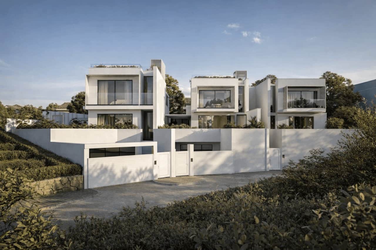
AZULIS Villas Dumas in Golfo Aranci — the closest RENTAL12 base for La Maddalena day trips. Photo RENTAL12.
Cagliari — coming soon
RENTAL12 Cagliari property under planning. Until then we recommend booking a partner near Poetto beach.
For more on Golfo Aranci as a base see our Golfo Aranci destination guide, our north Sardinia overview, and the broader Costa Smeralda context. Planning a longer trip? See our 7-day Sardinia itinerary.
10. Frequently asked questions
Plan your Sardinia parks trip from a proper local base
RENTAL12 owns and operates 37 properties across Olbia and Golfo Aranci — the right launchpad for La Maddalena and Gorropu, with a local team that points you to the right trail, the right ferry, and the right beach for today's wind. Owner-operated since 2021 — rated 4.9★ from 1,550+ 5 star reviews.
Rentamart24 is a paid affiliate partner — we earn a small commission at no extra cost to you. Rates and availability shown on rentamart24.com.
IUN F1530 / CIN IT090047B4000F1530 · Privacy